

A team from the Global Change-IPL Unit of the University of Valencia has just published in the International Journal of Applied Earth Observation and Geoinformation the first high-resolution local climate zone (LCZ) map of the city of Valencia, based on satellite data. The purpose of the study is to analyze the effects of 'heat island' and 'heat wave' in the main Mediterranean cities, and to provide mitigation measures to improve the environment and the health of the population
Increasingly intense, frequent and prolonged episodes of extreme heat in cities pose a threat to the environment and to the health of citizens. Counteracting these effects requires not only understanding their causes, but also designing strategies to adapt to the changing climatic conditions resulting from global warming.
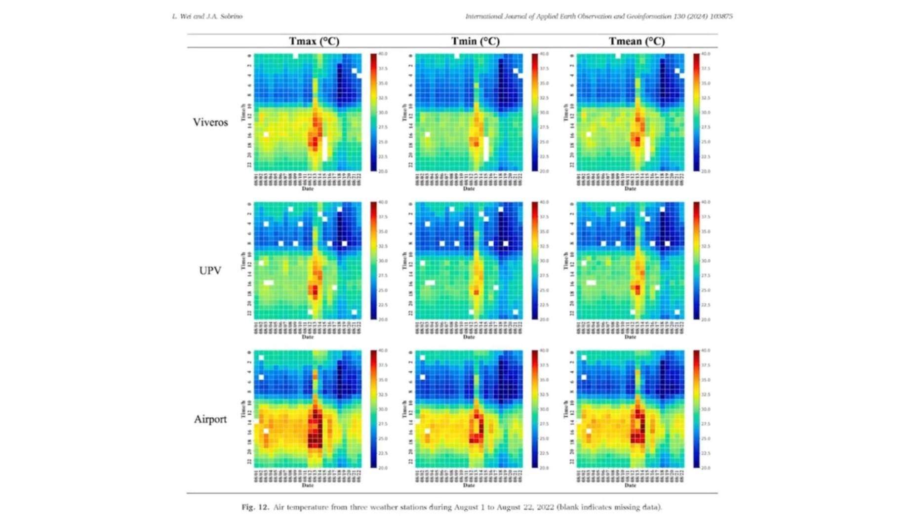
Based on the fact that the spatio-temporal dynamics of surface temperature is closely related to land cover -very heterogeneous in urban areas- and atmospheric conditions, the study conducted by the team from the University of Valencia (UV) has collected data from ECOSTRESS and Landsat satellites to monitor, at very high resolution, the land surface temperature (LST) in the city of Valencia (Spain). From a selection of 17 representative images during the periods of July and August 2022 and 2023, they have been able to monitor both the temperature and the urban surface heat islands (SUHI), i.e., the hot or critical points of the city. Thus, the first high-resolution map of local climate zones has been configured for Valencia city, which has become a model for the climate study of Mediterranean cities.
The results indicate which building types experience higher heat intensity and pinpoint particularly hot spots; they give evidence of the relationship between vegetation presence and nighttime cooling, and allow inferences, for example, that the low heat dissipation capacity of compact high-rise buildings produce a higher heat effect at night
Published in the International Journal of Applied Earth Observation and Geoinformation (Elsevier), the work samples the temperature of urban surfaces by zones - tracked on a 10-meter scale - and by temporal spaces - day and night -; it delimits heat islands and provides valuable information for urban and environmental policy makers to effectively address the problems associated with extreme weather.
The study details the specificity of each area according to the 'local climate zones - LCZ' classification scheme, a guide that provides urban planners and architects with a novel perspective on the influence that land cover exerts on the thermal dynamics of the urban environment. “Policy makers should closely monitor the buildings and surfaces most affected during heat waves and propose corresponding mitigation measures to improve the environment,” says José Antonio Sobrino, professor of Earth Physics and Thermodynamics at the UV, and principal investigator of this work carried out by the Global Change Unit (UCG) of the Image Processing Laboratory (IPL), located at the University of Valencia's Science Park.
The results indicate which building types experience higher heat intensity and pinpoint particularly hot spots; they give evidence of the relationship between vegetation presence and nighttime cooling, and allow inferences, for example, that the low heat dissipation capacity of compact high-rise buildings produce a higher heat effect at night.
Surface urban heat island analysis based on local climate zones using ECOSTRESS and Landsat data: A case study of Valencia city (Spain). Letian Wei, José A. Sobrino.
https://www.uv.es/uvweb/uv-noticias/es/noticias/olas-calor-amenazan-ambiente-nocturno-salud-ciudadanos-principales-ciudades-mediterraneas-1285973304159/Novetat.html?id=1286389685993&plantilla=UV_Noticies/Page/TPGDetaillNews